Norfolk District
Permit Application No. NAO-2024-2627 / VMRC# 25-1277
SAW-2024-1961
TO WHOM IT MAY CONCERN: The purpose of this notice is to advise the public that the following request associated with Southeast Supply Enhancement Project (SSEP) has been submitted for a Department of the Army (DA) permit under the provisions of, Section 404 of the Clean Water Act. In Executive Order (EO) 14156 the President declared a national emergency under the National Emergencies Act (50 U.S.C. 1621) based upon the finding that the United States’ insufficient energy production, transportation, refining, and generation constitutes an unusual and extraordinary threat to our Nation’s economy, national security, and foreign policy. The U.S. Army Corps of Engineers (Corps), Norfolk District has found that this permit request meets the terms of EO 14156 and is therefore subject to special emergency permitting procedures to address an energy supply situation which would result in an unacceptable hazard to life, a significant loss of property, or an immediate, unforeseen, and significant economic hardship if corrective action requiring a permit is not undertaken within a time period less than the normal time needed to process the application under standard procedures. The Norfolk District will implement the special processing procedures approved by North Atlantic Division in accordance with 33 CFR § 325.2(e)(4), however the applicant has requested that, where practical, the project review be completed under standard permitting procedures.
APPLICANT:
Joseph Dean
Transcontinental Gas Pipe Line Company, LLC
2800 Post Oak Boulevard, Suite 600
Houston, Texas 77056
AGENT:
Scott Burnsworth
GAI Consultants, Inc.
385 East Waterfront Drive
Homestead, Pennsylvania 15120
Christie Blevins
Wetland Studies and Solutions, Inc.
5300 Wellington Branch Drive, Suite 100
Gainesville, Virginia 20155
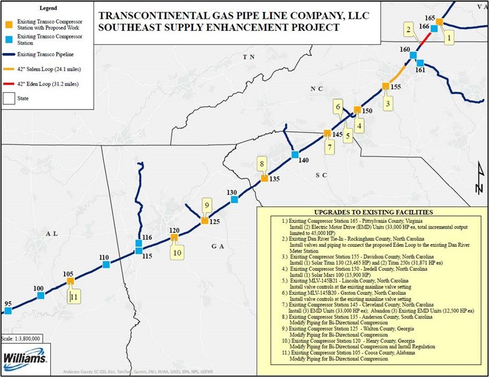
OVERALL PROJECT DESCRIPTION AND LOCATION: The SSEP is located in Virginia, North Carolina, South Carolina, Georgia, and Alabama as depicted in Figure 1. The SSEP consists of the installation of 55.3 miles of 42-inch-diameter natural gas pipeline (Virginia and North Carolina), additions to compression facilities (Virginia and North Carolina) and facility modifications (North Carolina, South Carolina, Georgia, and Alabama). The subject of this notice is specific to the actions of SSEP requiring a DA permit under the provisions of Section 404 of the Clean Water Act, which consists of the proposal to construct 55.3 miles of natural gas pipeline known as the Salem and Eden Loops (Project) located in North Carolina and Virginia.
Figure 1
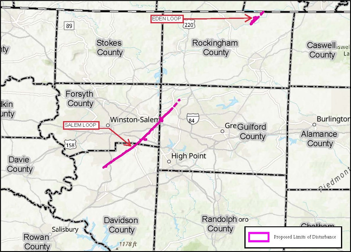
WATERWAY AND LOCATION: The Project would affect waters of the United States associated with the Dan River, Banister River, Cape Fear River, Yadkin Pee Dee River and their tributaries. The project area (Site) is located in Pittsylvania County in Virginia and Rockingham, Guilford, Forsyth, and Davidson Counties in North Carolina. The Eden Loop begins north of Transco Road in Chatham, Virginia (36.834228, -79.336743) and extends 24.1 miles southwest to the eastside of South Fieldcrest Road in Eden, North Carolina (36.493333, -79.681714). The Salem Loop begins on the east side of Sandylea Road in Oak Ridge, North Carolina (36.182162, -79.974310) and extends 31.2 miles southwest to the east side of George Hege Road in Lexington, North Carolina (35.930458, -80.261508).
Approximately 28.5 miles of the pipeline (Salem Loop and Eden Loop) is sited within the Corps Wilmington District. Proposed activities subject to Section 404 regulation within the Wilmington District’s regulatory boundary would occur within streams and wetlands within watersheds of the Dan River, Cape Fear River, and Yadkin Pee Dee River (Figure 2).
Figure 2
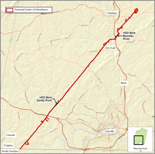
Approximately 26.8 miles of the pipeline (Eden Loop) is sited within the Corps Norfolk District. Proposed activities subject to Section 404 regulation within the Norfolk District’s regulatory boundary would occur within streams and wetlands within watersheds of the Dan River and Banister River (Figure 3).
Figure 3
EXISTING CONDITIONS: The project is collocated within or adjacent to the existing Transcontinental Pipeline (Transco). As such the Site is primarily comprised of mowed and maintained utility right-of-way (ROW). Approximately 91.5 percent of the Eden Loop and 99.4 percent of Salem Loop is collocated with existing ROWs.
PROJECT PURPOSE:
Basic: The applicant stated that the basic purpose is to expand Transco’s existing natural gas transmission system to enable Transco to provide additional natural gas in the Southeast.
Overall: The applicant stated that the overall purpose is to construct and operate the SSEP to provide an incremental 1,596,900 dekatherms per day (Dth/d) of year-round firm transportation capacity from Transco’s existing Station 165 Zone 5 Pooling Point and the Cherrystone Interconnect with Mountain Valley Pipeline located near Milepost (MP) 1413.0 in Pittsylvania County, VA, to growing natural gas markets in the southeastern United States.
PROPOSED WORK: The applicant requests authorization from the Wilmington District and Norfolk District to construct 55.3 miles of 42-inch-diameter natural gas pipeline. The overall project would result in the temporary discharge of dredged and/or fill material within 2.171 acres (17,623 linear feet) of stream channel and 21.806 acres of wetlands, and the permanent conversion of 2.424 acres of forested and scrub-shrub wetlands to emergent wetlands.
The applicant has request DA authorization for the following activities within the Wilmington District:
- Temporary discharge of dredged and/or fill material within 1.161 acres (11,652 linear feet) of stream channel;
- Temporary discharge of dredged and/or fill material within 11.186 acres of wetlands;
- Permanent conversion of 1.294 acres of forested and scrub-shrub wetlands to emergent wetlands.
The applicant has requested DA authorization for the following activities within the Norfolk District:
- Temporary discharge of dredged and/or fill material within 1.01 acres (5,971 linear feet) of stream channel for the construction of the of the pipeline and 120 square feet (10 linear feet) of stream channel for the construction of the permittee responsible mitigation site;
- Temporary discharge of dredged and/or fill material within 10.62 acres of wetlands for the construction of the of the pipeline and 3.34 acres of wetlands for the construction of the permittee responsible mitigation site;
- Permanent conversion of 1.13 acres of forested and scrub-shrub wetlands to emergent wetlands.
AVOIDANCE AND MINIMIZATION: The applicant has provided the following information in support of efforts to avoid and/or minimize impacts to the aquatic environment:
The applicant conducted a detailed hydraulic analysis to determine the necessary pipeline locations, lengths, and diameters to meet the purpose and need which resulted in the Project. The Project has been designed primarily collocated with the existing Transco pipeline and would deviate to minimize impacts to aquatic resources, comply with site-specific regulations, and/or for constructability. Where collocated, the applicant proposes that the construction ROWs would overlap with existing utility easements to minimize new disturbance to the extent practicable, although additional permanent ROW may be proposed to accommodate a 25-foot offset between pipe centerlines, to the extent practicable. The applicant proposes to limit the width of the construction ROW to 75-feet-wide or less to avoid additional impacts to wetlands where practicable. In addition, the wetland boundaries would be clearly flagged during construction to avoid potential unauthorized impact.
The Project would adhere to an approved erosion and sediment (E&S) plan during the construction, post-construction restoration, and operation of the Project to ensure that construction activities would be performed in accordance with applicable federal and state permit requirements. The applicant proposes dam and pump or flume crossing methods to perform dry open cut crossings to limit the potential for downstream impacts to waterbodies. For stream crossings with a top of bank width greater than 20-feet, the applicant is proposing to utilize v-lock interlocking concrete blocks to support construction mats across these streams for travel and ROW access. The applicant anticipates installing pipeline segments via dry open cut across streams less than 10 feet in width within 24 hours, and greater than 10 feet in width in under 48 hours, where practicable.
Where possible, the applicant designed stream crossings as near to perpendicular to the waterbody channel as engineering and routing conditions allow to minimize impacts. Project construction would comply with applicable time-of-year restrictions (TOYRs) subject to Federal Energy Regulatory Commission, US Fish and Wildlife Service and other relevant agencies requirements or the applicant would coordinate exceptions to those restrictions with the appropriate agencies. After the completion of construction, wetland areas within the ROW would be restored to pre-construction contours and revegetated with an approved seed mix, where standing water is not present, to stabilize disturbed soils. Topsoil would be replaced if temporarily removed, compacted soils would be de-compacted, and grubbing within wetlands would be limited to facilitate restoration. All temporarily impacted streams would be restored to their original bed and bank contours as closely as practicable. Prior to in-stream work, the top one foot of the streambed substrate would be segregated from the subsoils and stockpiled separately, where available. Silt fences, compost filter socks, and other E&S control barriers would be installed and maintained throughout the ROW until permanent vegetation is established. ROW maintenance would result in permanent conversion of existing upland and wetland forested areas to herbaceous or scrub-shrub vegetation communities. The construction ROW would be allowed to revert to preconstruction land use/land cover, with no further vegetation maintenance.
A copy of the joint permit application for the entirety of the proposed project route can be found on the Virginia Marine Resources Commission’s website at: https://webapps.mrc.virginia.gov/public/habitat/search_permits.php?id=20251277&msg=454
COMPENSATORY MITIGATION: The applicant offered the following compensatory mitigation plan to offset unavoidable functional loss to the aquatic environment:
The applicant has provided the following compensatory mitigation plan for activities within the Wilmington District area of responsibility:
- 1.29 wetland credits to offset the proposed wetland conversion at a 1:1 conversion to credit ratio;
- 2.01 wetland credits* for temporal loss of forested wetlands while they are allowed to regrow;
- 0.94 wetland credits* for the temporal loss of forested, scrub-shrub and emergent wetlands within the temporary construction limits of disturbance associated with the proposed impacts;
- 524.34 stream credits* for temporal loss of stream channel within the temporary construction limits of disturbance associated with the proposed impacts;
- The (*) following each credit amount above denotes voluntary mitigation credits according to the application;
- The applicant proposes to use private mitigation bank(s) credits to satisfy compensatory mitigation requirements and/or if credits are unavailable, through the use of the North Carolina Division of Mitigation Services in-lieu fee program.
The applicant has provided the following compensatory mitigation plan for activities within the Norfolk District area of responsibility:
- 1.13 wetland credits to offset the proposed wetland conversion at a 1:1 conversion to credit ratio;
- 1.81 wetland credits* to offset temporarily impacted forested wetlands at the mitigation ratio used for permanent conversion of wetlands (1:1) to account for the longer timeframe required to reestablish forested wetlands;
- 0.83 wetland credits* proposed for the temporal loss of wetland conversion impacts;
- 269 stream credits* for temporal loss of stream channel;
- The (*) following each credit amount above denotes voluntary mitigation credits according to the application;
- The applicant stated that no wetland credits are available that can serve the Project. As such, the applicant has proposed permittee-responsible mitigation (PRM) to satisfy the proposed wetland mitigation credits. The proposed PRM project referred to as “Cherrystone” is located adjacent to the Project, between MP 1410.50 and MP 1410 and a concept plan can be found on the Virginia Marine Resources Commission’s website at the link above. The applicant stated that they already purchased 269 stream credits from Frog Bottom Mitigation Bank.
CULTURAL RESOURCES: Pursuant to 36 CFR 800.2(a)(2) the Federal Energy Regulatory Commission is the lead Federal agency responsible for compliance with Section 106 of the National Historic Preservation Act for the proposed action. Any required consultation will be completed by the Federal Energy Regulatory Commission.
ENDANGERED SPECIES: Pursuant to Section 7 of the Endangered Species Act (ESA) any required consultation with the Service(s) will be conducted in accordance with 50 CFR part 402. The Federal Energy Regulatory Commission is the lead Federal agency for ESA consultation for the proposed action. Any required consultation will be completed by the Federal Energy Regulatory Commission.
ESSENTIAL FISH HABITAT: The Federal Energy Regulatory Commission is the lead Federal agency for Essential Fish Habitat consultation for the proposed action. Any required consultation will be completed by the Federal Energy Regulatory Commission.
There is no essential Fish Habitat within the Corps area of responsibility.
NAVIGATION: The proposed structure or activity is not located in the vicinity of a federal navigation channel.
SECTION 408: The applicant will not require permission under Section 14 of the Rivers and Harbors Act of 1899 (33 USC 408) because the activity, in whole or in part, would not alter, occupy, or use a Corps Civil Works project.
VIRGINIA'S COASTAL ZONE MANAGEMENT PROGRAM: For compliance with the Coastal Zone Management Act of 1972, as amended for projects located in Virginia's Coastal Zone, the applicant must certify that federally licensed or permitted activities affecting Virginia's coastal uses or resources will be conducted in a manner consistent with the Virginia's Coastal Zone Management Program (Virginia CZM Program), and obtain concurrence from the Department of Environmental Quality (DEQ), Office of Environmental Impact Review (OEIR). It is the applicant's responsibility to submit a consistency certification to the OEIR for concurrence or objection, and proof of concurrence must be submitted to the Corps prior to final permit issuance. A template federal consistency certification can be found in the Federal Consistency Manual here: https://www.deq.virginia.gov/our-programs/environmental-impact-review/federal-consistency
For more information or to obtain a list of the enforceable policies of the Virginia CZM Program, contact the DEQ-OEIR at (804) 659-1915 or e-mail: bettina.rayfield@deq.virginia.gov.
No concurrence is required because the project is not located within Virginia's Coastal Zone.
VIRGINIA WATER QUALITY CERTIFICATION: Water Quality Certification may be required from the Virginia Department of Environmental Quality. The Clean Water Act (CWA) Section 401 Certification Rule (Certification Rule, 40 CFR 121), effective September 11, 2020, requires certification, or waiver, for any license or permit that authorizes an activity that may result in a discharge. The scope of a CWA Section 401 certification is limited to ensuring that a discharge from a Federally licensed or permitted activity will comply with water quality requirements. To comply with the Virginia Section 401 Water Quality Certification Program and the Certification Rule, the applicant is responsible for adhering to the procedures outlined in the Certification Rule when requesting certification from the certifying authority, the Virginia Department of Environmental Quality. In accordance with Certification Rule part 121.12, the Corps will notify the U.S. Environmental Protection Agency Administrator when it has received a Department of the Army (DA) permit application and the related certification. The Administrator is responsible for determining whether the discharge may affect water quality in a neighboring jurisdiction. The DA permit may not be issued pending the conclusion of the Administrator's determination of effects on neighboring jurisdictions.
NOTE: This public notice is being issued based on information furnished by the applicant. This information has not been verified or evaluated to ensure compliance with laws and regulation governing the regulatory program. The geographic extent of aquatic resources within the proposed project area that either are, or are presumed to be, within the Corps jurisdiction has been verified by Corps personnel.
EVALUATION: The decision whether to issue a permit will be based on an evaluation of the probable impact including cumulative impacts of the proposed activity on the public interest. That decision will reflect the national concern for both protection and utilization of important resources. The benefits, which reasonably may be expected to accrue from the proposal, must be balanced against its reasonably foreseeable detriments. All factors which may be relevant to the proposal will be considered including cumulative impacts thereof; among these are conservation, economics, esthetics, general environmental concerns, wetlands, historical properties, fish and wildlife values, flood hazards, floodplain values, land use, navigation, shoreline erosion and accretion, recreation, water supply and conservation, water quality, energy needs, safety, food, and fiber production, mineral needs, considerations of property ownership, and in general, the needs and welfare of the people. Evaluation of the impact of the activity on the public interest will also include application of the guidelines promulgated by the Administrator, EPA, under authority of Section 404(b) of the Clean Water Act or the criteria established under authority of Section 102(a) of the Marine Protection Research and Sanctuaries Act of 1972. A permit will be granted unless its issuance is found to be contrary to the public interest.
COMMENTS: The Corps is soliciting comments from the public; Federal, State, and local agencies and officials; Indian Tribes; and other Interested parties in order to consider and evaluate the impacts of this proposed activity. Any comments received will be considered by the Corps to determine whether to issue, modify, condition, or deny a permit for this proposal. To make this determination, comments are used to assess impacts to endangered species, historic properties, water quality, general environmental effects, and the other public interest factors listed above. Comments are used in the preparation of an Environmental Assessment (EA) and/or an Environmental Impact Statement pursuant to the National Environmental Policy Act (NEPA). Comments are also used to determine the need for a public hearing and to determine the overall public interest of the proposed activity.
PRIVACY AND CONFIDENTIALITY: Comments and information, including the identity of the submitter, submitted in response to this Public Notice may be disclosed, reproduced, and distributed at the discretion of the U.S. Army Corps of Engineers. Information that is submitted in connection with this Public Notice cannot be maintained as confidential by the U.S. Army Corps of Engineers. Submissions should not include any information that the submitter seeks to preserve as confidential.
The Wilmington District will receive written comments on the proposed work, as outlined above, pertaining to both the Wilmington District and Norfolk District areas of responsibility, until July 28, 2025. Comments should be submitted electronically via the Regulatory Request System (RRS) at https://rrs.usace.army.mil/rrs. Please reference Corps project number SAW-2024-01961 for all comments on the project. Alternatively, you may submit comments in writing to the Commander, U.S. Army Corps of Engineers, Norfolk District, Attention: George Lyle Phillips III, 3331 Heritage Trade Drive, Suite 105, Wake Forest, North Carolina 27587. Please refer to the permit application number in your comments.
Any person may request, in writing, within the comment period specified in this notice, that a public hearing be held to consider the application. Requests for public hearings shall state, with particularity, the reasons for holding a public hearing. Requests for a public hearing will be granted, unless the District Engineer determines that the issues raised are insubstantial or there is otherwise no valid interest to be served by a hearing.