Authorization:
Continuing Authorities Program Section 204, Water Resources Development Act of 1992, as amended: beneficial use of dredged material from an authorized federal navigation channel for the protection, restoration, and creation of aquatic and related habitats.
Study/Project Summary:
The lead Federal agency for the feasibility study is the U.S. Army Corps of Engineers (USACE). The non-Federal sponsor for this study is the Commonwealth of Virginia, acting through its agent, the Virginia Marine Resource Commission (VMRC).
Cedar Island is a barrier island located within the Delmarva Peninsula off the coast of Wachapreague, Virginia. The western side of Cedar Island (referred to as the Cedar Island Back-barrier) is flanked by channels, shoreline wetlands and marsh islands, lagoons, and mudflats. The Cedar Island Back-barrier shoreline wetlands and marsh islands are a fragile ecosystem at risk of loss due to the threats of erosion, sea level rise, and subsidence. The Cedar Island Back-barrier provides substantive fish and wildlife habitat hosting foraging grounds for migratory bird species and provides important nursery habitat for commercial and recreational fisheries.
The purpose and need of this study is to beneficially use dredged material to enhance and/or restore the Cedar Island Back-barrier tidal wetlands, a fragile ecosystem at risk of loss via a sustainable approach that will also protect tidal shoreline wetlands and marsh islands subjected to the continuing threats of erosion, climate change, and sea level rise.
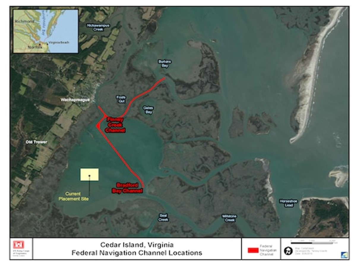
The primary goal of this study is to beneficially use the dredged material from the Finney Creek Channel and the Bradford Bay Channel for restoration and/or enhancements of the Cedar Island back-barrier tidal shoreline wetlands and/or marsh islands.
The study objectives include the following:
• Restore and/or enhance tidal shoreline wetlands and/or marsh islands to enhance fish and wildlife habitat;
• Incorporate a long-term, sustainable solution to reduce tidal wetland erosion rates and increase sediment accretion rates;
• Create more suitable wetland elevations for tidal shoreline wetlands and/or marsh islands; and
• Adaptively manage restoration and/or enhancement site(s) to address sea level, subsidence, and erosion rise threats.
This Final Integrated Feasibility Report/Environmental Assessment (IFR/EA) has been prepared by the USACE, Norfolk District to develop and evaluate the feasibility of alternatives to beneficially use dredged material from Finney Creek Channel and the Bradford Bay Channel for the purpose of enhancement and/or restoration of the Cedar Island Back-barrier marsh wetlands located off the coast of Wachapreague, Virginia. This evaluation resulted in the recommendation of a Recommended Plan, also referred to as the Preferred Alternative for purposes of the National Environmental Policy Act of 1969, as amended (NEPA). In accordance with regulations implementing NEPA, this IFR/EA compares the environmental consequences of the alternatives and identifies a Recommended Plan. The Recommended Plan (or Preferred Alternative) is the National Ecosystem Restoration, Best Buy Plan as determined by the Cost Effectiveness/Incremental Cost Analysis (CE/ICA). This plan serves to maximize environmental benefits for the best value.
Study sponsor:
Virginia Marine Resource Commission is currently the non-Federal sponsor for the Feasibility Study and VMRC is anticipated to be the non-Federal sponsor for the Design & Implementation (DI) Phase.
Recommended Plan:
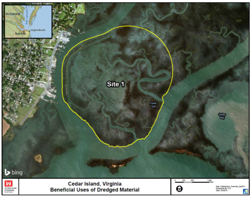
The Recommended Plan is Alternative 1A which consists of thin-layer spraying of dredged material over a portion of the Fools Gut Marsh Island located in the Cedar Island Back-barrier, Virginia. Alternative 1A is located at Site 1 which is 194 acres and is located at the southern portion of the Fools Gut Marsh Island that is located across then avigation channel from the Wachapreague Marina. The thin-layer spraying would be done via a hydraulic cutterhead dredge equipped with a pipeline that would spray the dredged material from the Finney Creek Channel and the Bradford Bay Channel to the southern portion of the Fools Gut Marsh Island at Site 1.
The quantity of dredged material sprayed during each treatment of the wetland site would be approximately 77,435 cubic yards. For planning purposes this allows for an approximately six-inch thin-layer spraying across the project site; however, actual thin-layer placement target application elevations would be determined by the topographic survey to be conducted prior to each thin-layer spraying application.
The assumed project lifecycle is approximately 50 years. The project construction is anticipated to begin in year 2027 with the initial thin layer spraying to occur over the 194 acres in Site 1. Topographic surveys followed by thin-layer spraying would then occur over the site as needed in years 2041 and 2055. The rehabilitations are assumed to use approximately the same dredging volume as the initial dredged material placement. This schedule was chosen to coincide with the dredging maintenance cycle that supports the Bradford Bay and Finney Creek Channels and anticipated sea level rise effects to ensure we spray at appropriate timeframes to ensure the marsh island is properly maintained.
Implementation of Alternative 1A would serve to enhance and restore 174 acres of tidal marsh island serving to provide substantive ecological benefits to enhance and sustain the marsh vegetation diversity, fish foraging and nursery habitat, and migratory bird habitat. A quantitative Eco modeling analysis was conducted with the New England Marsh Model to assess projected marsh habitat benefits; this analysis showed that 108.02 wetland habitat units would be provided with implementation of Alternative 1A.
The total project first cost of the Recommended Plan, which includes costs for preparation of plans and specifications, construction costs, construction management, and lands and damages is estimated to be approximately $5,536,000 (Fiscal Year 2019 Price level). The total fully funded cost, with escalation through the midpoint of each construction element is estimated at $11,258,000 with 65% Federal cost share $7,318,000 and 35% non-Federal cost share $3,940,000. The non-Federal Sponsor is required to provide the non-Federal cost share during project construction and all lands, easements, and rights-of-way necessary for the construction, operation, and maintenance of the project.
All practical means to avoid or minimize adverse environmental effects were analyzed and incorporated into the Recommended Plan. Best management practices (BMPs) as detailed in the IFR/EA would be implemented to minimize potential impacts. No natural resource compensatory mitigation would be required.
Location of the Recommended Plan:
Schedule:
|
Current
|
Key Action
|
|
24 OCT 2019 (Actual)
|
CAP Feasibility Final Report Approval
|
|
TBD
|
District Executes Project Partnership Agreement (PPA)
|
|
TBD
|
Construction Funding Received
|
|
TBD
|
Start Plans & Specifications
|
|
TBD
|
60% Plans & Specifications
|
|
TBD
|
90% Plans & Specifications
|
|
TBD
|
Plans & Specifications Approval
|
|
TBD
|
USACE HQ Commits Construction Funding
|
|
TBD
|
Ready to Advertise (RTA)
|
|
TBD
|
Contract Award
|
|
TBD
|
Notice to Proceed
|
|
TBD
|
Construction Start Date
|
|
TBD
|
Project Physical Completion
|
|
TBD
|
Project Fiscal Completion
|
If you have comments or questions, contact Richard Harr of USACE Norfolk District at richard.m.harr@usace.army.mil or 757-201-7746. They can also be sent via regular mail to: U.S. Army Corps of Engineers Norfolk District, ATTN: Richard Harr, 803 Front St., Norfolk, VA 23510.